FG/IK2JYT Giovanni - A.r.i. Lomazzo (Co)
FG/IK2XDE Andrea - A.r.i. Lomazzo (Co)
FG/IK2HAB Mario - A.r.i. Erba (Co)
FG/IW2MVS Luigi - A.r.i. Lomazzo (Co)
DXCC: FG - Guadeloupe Is. (FG)
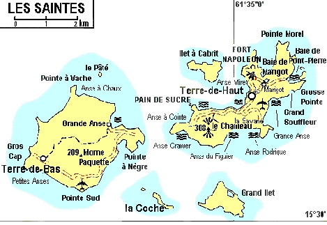
IOTA: NA-114 (Les Saintes)
DIFO: FG-011 (Terre de Haut)
DIFO: FG-002 (Ilet a Cabrit)
WW-Locator: FK95FU
Rigs
N. 2 ICOM IC-706MKII
N. 2 Fiberglass Tower 10Mt. (by DK9SQ)
N. 2 Multiband Loop Antenna (by DK9SQ)
N. 2 Laptop computer for logging
N. 1 Laptop computer for RTTY
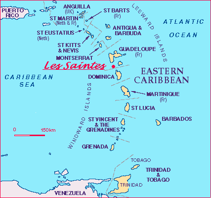
Historical & Geografical Infos
Political: Part of the French Departement of Guadeloupe
Population: 3000 inhabitants
Principal Town: Terre de Haut
Surface Area: 1467 hectares
Highest Point: 308 meters (Le Chameau)
The small archipelago of "Les Saintes", of a total surface area of 14 Kmq,
is formed by two main islands: Terre de Haut and Terre de Bas.
It is situated about 10 Kms south of the coast of Guadeluope.
It was discovered by Christopher Columbus durind his second expedition,
on the 3rd November 1493.
The archipelago has developed with the tourist trade,
a network of maritime ferries ensures the daily liason with Gaudeluope.
The most tourist frequented part of the archipelago is Terre de Haut,
with his harbour, and a beautiful bays of fine golden sand indeed a small paradise on earth!